Latest Post

Deviated Well (Directional)

Deviated Well (Directional):
---------------------------------

1) -TVD: True Vertical Depth which is the vertical distance from a point in the well to a point at the rotary table.

2) -TVDss: true Vertical Depth Sub Sea which is the vertical distance from a point in the well to the mean seal level.

3) -MD: Measured Depth (always>TVD)

4) Ө: Angle of inclination which is angle of deviated well with respect to its vertical origin

5) A: Azimuth which is angle of deviated well with respect to Magnetic North
Pole.
 

Vertical Well

Vertical Well:

-RT: is the Rotary Table

-MD: is the Measured Depth which is the distance between the rotary table to the end of well.

-KB: is the Kelly Bushing which is the distance between rotary table & the mean seal level (MSL)

-MDss: is the Measured depth sub sea which is the distance between mean sea level (MSL) to the end of well (MDss=MD-KB).
 

Australian oil and gas company Recruitment 2014 : Senior Drilling Engineer


Australian oil and gas company Recruitment 2014 : Senior Drilling Engineer

One of Our Client is an independent Australian oil and gas company playing a key role in supplying energy to our region. They are one of the worlds leading producers of liquefied natural gas, helping meet the demands for cleaner energy from Japan, China, Korea and other countries in the Asia Pacific region.

The Role:
Working as part of our clients Development division, youll join their Drilling & Completion Team.
This team is responsible for the design, construction, maintenance and abandonment of all company well assets.

In 2014 we will commence a deepwater & shallow/mid water operation.
Planning work will also commence for international drilling.

You will deliver drilling engineering input into the design of exploration, appraisal and development wells consistent with the Drilling & Completions Management System.
You will supervise and mentor Drilling and Well Engineers, provide technical line review and prepare Drilling Engineering Programmes & Execution Procedures and assure compliance with regulatory requirements for well construction, including preparation of documentation for Government approval.
Other responsibilities will include providing support to the offshore rig teams, providing input to project teams in screening new opportunities and working with other functions to resolve key decisions.

Essential Skills / Qualifications:
You will have an engineering degree coupled with at least 10 years relevant experience.

Your excellent communication and interpersonal skills will allow you to build strong relationships with internal and external clients.

A strong team work ethic will assist your team with their planning and managing of competing workloads under time-related constraints.
astamper@fircroft.com, 9262 6209


Chevron Open Recruitment 2013 : Various Positions


At Chevron, you wil have a chance to being take part in some of the most important energy projects in Indonesia’s history. We’re pioneering new techniques in enhanced-oil recovery. And we’re now currently developing this nation’s first ultra-deepwater natural gas well. WithChevron, you’ll join with the team with the technology which to take on big challenges, the integrity to do it responsibly, and the drive to keep the world keep moving forward.

We are hiring experience engineers, and oil and professionals Less than 4 years experience

- Lead Facility Engineer (FEFW Coordinator)
- Facility Engineer
- Facility Engineer – Project
- Facility Engineer Project Leader
- Completion Engineer
- Contract Engineer
- Cost Engineer
- Drilling Engineer
- Drilling Engineer Planning
- HES Due Diligence Engineer


- HES Engineer
- HES Engineer Field DMI & HCT Information Management Specialist
- Lead Petroleum Engineer
- Petroleum Engineer
- Production Engineer
- Reservoir Engineer
- Project Engineer

If you’re up to the job, visit www.chevron.formycareer.com by 22 December 2013.


Diastrophism


Diastrophism

diastrophism, also called tectonism, large-scale deformation of Earth’s crust by natural processes, which leads to the formation of continents and ocean basins, mountain systems, plateaus, rift valleys, and other features by mechanisms such as lithospheric plate movement (that is, plate tectonics), volcanic loading, or folding.

The study of diastrophism encompasses the varying responses of the crust to tectonic stresses. These responses include linear or torsional horizontal movements (such as continental drift) and vertical subsidence and uplift of the lithosphere (strain) in response to natural stresses on Earth’s surface such as the weight of mountains, lakes, and glaciers. Subsurface conditions also cause subsidence or uplift, known as epeirogeny, over large areas of Earth’s surface without deforming rock strata. Such changes include the thickening of the lithosphere by overthrusting, changes in rock density of the lithosphere caused by metamorphism or thermal expansion and contraction, increases in the volume of the asthenosphere (part of the upper mantle supporting the lithosphere) caused by hydration of olivine, and orogenic, or mountain-building, movements.

Orogenic
it is marked by deformation of the earth's crust ,including radial and slow deformation. orogeny, mountain-building event, generally one that occurs in geosynclinal areas. In contrast to epeirogeny, an orogeny tends to occur during a relatively short time in linear belts and results in intensive deformation. Orogeny is usually accompanied by folding and faulting of strata, development of angular unconformities (interruptions in the normal deposition of sedimentary rock), and the deposition of clastic wedges of sediments in areas adjacent to the orogenic belt. Regional metamorphism and magmatic activity are often associated with an orogenic event as well. Orogenies may result from subduction, terrane accretion (landmass expansion due to its collision with other landmasses.

This diagram depicts some common fold types


Fault Types


Epeirogenic regional up lift of the crust which result in large scale deformation .

-involves vertical movement of crust .
-not involves severe deformation of the crust .
-causes submergence of cratons by several thousand of meters

Epeirogenic movement can be permanent or transient. Transient uplift can occur over a thermal anomaly due to convecting anomalously hot mantle, and disappears when convection wanes. Permanent uplift can occur when igneous material is injected into the crust, and circular or elliptical structural uplift (that is, without folding) over a large radius (tens to thousands of km) is one characteristic of a mantle plume.

Epeirogenic movement has caused the southern Rocky Mountain region to be uplifted from 1300 to 2000 m since the Eocene.This followed and is distinct from the creation of the Rocky Mountains during the Laramide Orogeny during the Late Cretaceous–early Cenozoic. The uplift is interpreted as due to lithospheric heating resulting from thinning and the intrusion of widespread middle Tertiary batholiths of relatively low density.

In contrast to epeirogenic movement, orogenic movement is a more complicated deformation of the Earth's crust, associated with crustal thickening, notably associated with the convergence of tectonic plates. Such plate convergence forms orogenic belts that are characterized by “the folding and faulting of layers of rock, by the intrusion of magma, and by volcanism


RELIEF FEATURES


RELIEF FEATURES

Various type of landform of the Earth’s crust classified under three orders of magnitude:

The first order comprises continents and Oceans which are the largest features on the Earth. The configurations of continents & ocean basins haven't remain static such as sea floor spreading and faults. Many ancient features have understandably dissolved in the mists of time. However, geoscientists have pieced together evidences which show that parts of the earth’s crust had been elevated and depressed, extensive stretched of dry lands of the present day were under water, violent episodes of volcanic activity and impact of extra-terrestrial bodies has scared the earth’s face and mountain ranges had been heaved up and worn down.

The second order comprises mountains and plains which have resulted by the action of the internal forces of the earth. Such action of forces emanating from deep within the bowels of the earth includes both orogenic and epeirogenic movements.

The third order features result by the action destructional force and give rise to residual features of peaks, erosional features including valleys and canyons and depositional features like deltas. Also, weathering, streams, waves, wind and glaciers produce relief features of the third order.

First order landforms:

The slope element of the Earth:

-deep sea platform of the ocean

- Continental slope

- Continental shelf

- Continental platform 


The earth's surface is inhomogeneous:

1. 70.8 % of the earth's surface are under water.

2. 29.2 % of the land continents

3. Land and sea are mostly antipodal arranged. Only1.5 % of the surface has land antipodal to land.

4. About two-third of land is in northern hemisphere

5. The deepest parts of oceans aren't always far out from the land and are often located clothe to mountain ranges as in Island arcs

Major topographic element:

1- Ocean ridges:

Wide oceans has brought to light traversal fractured linear ridges extending over a distance of about 64000 K m with width of 2000-4000 Km and rise from 1-3 Km from the ocean floor.

Examples:

The Atlantic & Indian ocean are irregular.
The east pacific ridge is smooth arch.
The mide Atlantic ridge is characterized by 25 – 50 Km wide axial rift valleys.

The Carlsberg ridge is a branch of Indian ocean ridge, branches off towards the north, enters the Gulf of Aden and thence the red sea.
Southerly branch runs through the rift valley system of East Africa.
The East pacific ridge isn't marked by central rift valleys; it’s bordered by faulted steps, ridges & troughs.
Ridges are tectonically unstable marked by shallow earthquakes, high heat flow & volcanic activity

2-Ocean basins:

The ocean basins flanking the mid – ocean ridges are abyssal plains which characterized by hills and sea mounts.
The abyssal plains are tectonically inactive and have gentle gradients of less than 1:1000.They are known to be up to 1000 Km in width below water columns measuring 3-6 Km in depth. They are found to increase in thickness toward the continental slope and shelf.
The sea mount in the bed are spectacular features with width 2-100 Km and rising to dizzy heights of more than 1000 m from the abyssal plain
Sea mounts have sharply pointed and flat tops and they are in the form of hills whose tops are in some cases below a water column of 200 meters.
Guyots: are steep-sided seamounts (12o- 35o) appearing to have ware leved platforms whose submergence is attributed to sea-floor subsidence and rise in water level in post –glacial time.

Continental slope and rise:

The present shoreline of ocean does not limit the extent of continental rocks. The outer edge of the continental shelf, approximately located 0.135 kilometers below the sea level delimits the continental rock.

Continental slope is the part leads into the deep sea, from its outer edge descends at slope up to 6o to depth of two kilometers. Continental sediments in the form of coalescing fans and aprons mark the base of continental slope. In seaward extension of large rivers, submarine canyons mark the continental shelf and slope.

Continental rise is a wide, gentle incline from an ocean basin to a continental slope. A continental rise consists mainly of silts, muds, and sand, and can be several hundreds of miles wide. Although it usually has a smooth surface, it is sometimes crosscut by submarine canyons.

3 - Ocean Trenches, deeps or troughs:
Oceans trenches define the deepest parts of ocean floor. They are known to be variable in length (300 – 5000 Km) and 30 – 100 Km in width, with slopes of 10o – 16o in their deeper parts. The trenches run parallel to island arcs or younger volcanic zones on their seaward side.

4- Island Arcs:

Most ocean trenches on their landward side are marked by parallel accurate festoons of islands. In certain cases, they are topographically and structurally continuous with continental belts of young folded mountains. They are tectonically active zones with profound seismicity.

5- Marginal Sea Basins:

They occur between island arcs and continents. Some of them are 500 to 1000 Km wide and have rugged bottoms with faults, undulations and small sea-mounts characterizing complex histories and different sediment sources. Both tectonically active and inactive basins are known

6- Folded Mountains

It is formed in sediments under the impact of compression. Folding, thrusting and uplift are thrown up as curvilinear mountain chains which may be associated with volcanic activity, deep igneous emplacement and metamorphism.
Broadly, folded mountains may be divided into older and younger groups. The older groups have medium scale elevations and are tectonically more stable than younger group. The younger groups include mountains of highest terrestrial elevations like ALPS and Himalayas.


Basic concepts and significance of geomorphology


Basic concepts and significance of geomorphology
Geomorphology means a discourse on earth forms. The Geomorphological studies encompass landforms of the continents, their margins and the sea floor.

Landforms are studied from three different points of view:

‐The geologist looks into the geological controls in the evolution of landforms. In the study of landforms by geologists, understanding the historical and dynamic elements of the process that change the geological materials and structure is very important.
‐The geographer concerns with the adjustment of human activities in charging landforms.
‐The engineer assesses the terrain from the point of view of engineering construction and availability of materials for construction.


Sources and time of geomorphological activities:

All geological and geomorphological activities of the earth are due to endogenetic and exogenetic sources of energy. Example of endogenitic sources is the convection currents in the mantel that may produce earthquake, volcanoes and plate movements. Exogenetic sources may be represented by the solar radiation,
gravitational attraction and biological processes.

Landform units are studied not only with the reference to their magnitude, but also to the time it is taken to be formed. The time of the evoluti

on of geomorphological landforms ranges from few minutes (ex. Ripple marks) to long period of millions of years (ex. Mountainous chains).


Concepts of geomorphology


During the fifteens and sixteen evolution of landforms was based on the philosophy of catastrophism until James Hutton (1726 – 1797) has changed it to scientific though with his principle of uniformitarianism. This leads to the

main concepts of geomorphology which are as follows:

First concept depends on the principle of uniformitarianism that conveys that the present is the key of the past. James Hutton applied this principle rigidly and stated that geological processes have been active at the same level of intensity throughout the geological time. IT IS NOW RECOGNISED THAT IT IS NOT TRUEthat the physical processes and laws which are in operation during the present time were active in the geological past, but notnecessarily with the same intensity as now.

Second concept: that in the evaluation of landforms, structure such as joint, folds, fault and permeability plays a crucial role and is reflected in the landforms. Geomorphic features developed on rocks are in general much younger to the structural features of the rocks.

Third concept is that geomorphic process operates not on a uniform rate but at differential rates resulting in the evolution of relief features. The processes are affected by many factors as altitude, temperature, moisture, type of vegetation and microclimatic condition.

Fourth concept that geomorphic processes produce distinctive imprints on landforms and characteristic assemblage of landforms evolve as a result to the operation of different geomorphic processes. For example, deltas and alluvial fans result by stream action where caves in limestone terrain are attributed to ground water

Fifth concept states that according to W. Davis (1850‐1934) thought that landforms display distinctive characteristic depending on the stage of their development. So that the evolution of landforms is through youth, maturity and old age stages. Though many geomorphologiste are not convinced of this
concept, because an orderly sequence of landforms come into being by the action of different erosional agents on the earth’s surface.

Sixth concept is that geomorphic evolution is one of complexity then simplicity. In one geomorphic process or cycle, remnants of landforms not related to the current cycle of erosion are recognized. Five categories of landforms including simple, compound, monocyclic, multicyclic and exhumed have been recognized.
 

Archean Eon


Archean Eon

Classification issues

Instead of being based on stratigraphy as all other geological ages are, the beginning of the Archean eon is defined chronometrically. The lower boundary (starting point) of 4 billion years is officially recognized by the International Commission on Stratigraphy.

The Archean customarily starts at 4 Ga—at the end of the Hadean Eon. In older literature, the Hadean is included as part of the Archean. The name comes from the ancient Greek Αρχή (Arkhē), meaning 
"beginning, origin".


Earth

The Archean is one of the four principal eons of Earth history. When the Archean began, the Earth's heat flow was nearly three times as high as it is today, and it was still twice the current level at the transition from the Archean to the Proterozoic (2,500 Ma). The extra heat was the result of a mix of remnant heat from planetary accretion, heat from the formation of the Earth's core, and heat produced by radioactive elements.

Most surviving Archean rocks are metamorphic or igneous. Volcanic activity was considerably higher than today, with numerous lava eruptions, including unusual types such as komatiite. Granitic rocks predominate throughout the crystalline remnants of the surviving Archean crust. Examples include great melt sheets and voluminous plutonic masses of granite, diorite, layered intrusions, anorthosites and monzonites known as sanukitoids.

The Earth of the early Archean may have supported a tectonic regime unlike that of the present. Some scientists argue that, because the Earth was much hotter, tectonic activity was more vigorous than it is today, resulting in a much faster rate of recycling of crustal material. This may have prevented cratonisation and continent formation until the mantle cooled and convection slowed down. Others argue that the oceanic lithosphere was too buoyant to subduct, and that the rarity of Archean rocks is a function of erosion by subsequent tectonic events. The question of whether plate tectonic activity existed in the Archean is an active area of modern research.


There are two schools of thought concerning the amount of continental crust that was present in the Archean. One school maintains that no large continents existed until late in the Archean: small protocontinents were the norm, prevented from coalescing into larger units by the high rate of geologic activity. The other school follows the teaching of Richard Armstrong, who argued that the continents grew to their present volume in the first 500 million years of Earth history and have maintained a near-constant ever since: throughout most of Earth history, recycling of continental material crust back to the mantle in subduction or collision zones balances crustal growth.

Opinion is also divided about the mechanism of continental crustal growth. Those scientists who doubt that plate tectonics operated in the Archean argue that the felsic protocontinents formed at hotspots rather than subduction zones. Through a process called "sagduction", which refers to partial melting in downward-directed diapirs, a variety of mafic magmas produce intermediate and felsic rocks. Others accept that granite formation in island arcs and convergent margins was part of the plate tectonic process, which has operated since at least the start of the Archean.

An explanation for the general lack of Hadean rocks (older than 3800 Ma) is the efficiency of the processes that either cycled these rocks back into the mantle or effaced any isotopic record of their antiquity. All rocks in the continental crust are subject to metamorphism, partial melting and tectonic erosion during multiple orogenic events and the chance of survival at the surface decreases with increasing age. In addition, a period of intense meteorite bombardment in the period 4.0-3.8 Ga pulverized all rocks at the Earth's surface during the period. Some think that the similar age of the oldest surviving rocks and the "late heavy bombardment" is not coincidental.
Palaeoenvironment
The Archean atmosphere is thought to have nearly lacked free oxygen. Astronomers think that the sun had about 70–75% of the present luminosity, yet temperatures appear to have been near modern levels even within 500 Ma of Earth's formation, which is puzzling (the faint young sun paradox). The presence of liquid water is evidenced by certain highly deformed gneisses produced by metamorphism of sedimentary protoliths. The equable temperatures may reflect the presence of larger amounts of greenhouse gases than later in the Earth's history. Alternatively, Earth's albedo may have been lower at the time, due to less land area and cloud cover.

By the end of the Archaean c. 2500 Ma (million years ago), plate tectonic activity may have been similar to that of the modern Earth. There are well-preserved sedimentary basins, and evidence of volcanic arcs, intracontinental rifts, continent-continent collisions and widespread globe-spanning orogenic events suggesting the assembly and destruction of one and perhaps several supercontinents. Liquid water was prevalent, and deep oceanic basins are known to have existed by the presence of banded iron formations, chert beds, chemical sediments and pillow basalts.

Geology

Although a few mineral grains are known that are Hadean, the oldest rock formations exposed on the surface of the Earth are Archean or slightly older. Archean rocks are known from Greenland, the Canadian Shield, the Baltic Shield, Scotland, India, Brazil, western Australia, and southern Africa. Although the first continents formed during this eon, rock of this age makes up only 7% of the world's current cratons; even allowing for erosion and destruction of past formations, evidence suggests that continental crust equivalent to only 5-40% of the present amount formed during the Archean.

In contrast to Proterozoic rocks, Archean rocks are often heavily metamorphized deep-water sediments, such as graywackes, mudstones, volcanic sediments, and banded iron formations. Carbonate rocks are rare, indicating that the oceans were more acidic due to dissolved carbon dioxide than during the Proterozoic.Greenstone belts are typical Archean formations, consisting of alternating units of metamorphosed mafic igneous and sedimentary rocks. The meta-igneous rocks were derived from volcanic island arcs, while the metasediments represent deep-sea sediments eroded from the neighboring island arcs and deposited in a forearc basin. Greenstone belts represent sutures between protocontinents.
Life
Fossils of cyanobacterial mats (stromatolites, which were instrumental in creating the free oxygen in the atmosphere ) are found throughout the Archean, becoming especially common late in the eon, while a few probable bacterial fossils are known from chert beds. In addition to the domain Bacteria (once known as Eubacteria), microfossils of the domain Archaea have also been identified.

Life was probably present throughout the Archean, but may have been limited to simple non-nucleated single-celled organisms, called Prokaryota (formerly known as Monera). There are no known eukaryotic fossils, though they might have evolved during the Archean without leaving any fossils. No fossil evidence has been discovered for ultramicroscopic intracellular replicators such as viruses.


Note : The above story is based on materials provided by Wikipedia
 

Secondary Sedimentary Structures

Secondary Sedimentary Structures

Bedding plane structures
Another class of sedimentary structures form on the interface between beds, usually on the exposed surface of a recently deposited bed before it is buried. These features are useful because they indicate current direction and post-depositional deformation of the sediment.
Sole marks are formed by currents acting on sediment.
  • Flute casts: Elongate teardrop shaped depressions that taper upstream. Caused by the scouring action of turbulent flow, common in turbidity currents.
  • Tool mark: Indention of the cohesive mud bottom by a "tool," and object dragged across sediment by current (right).

Mud cracks Indicate subaerial exposure. Recent 
Rain drop prints 
Geopetal structures indicate the top of beds, and these can be found as:
  • Scoured tops of ripple crests yielding truncated cross-bedding. (Recent.) (Ancient.)
  • Graded bedding
  • Infilling of fossils or vugs (right).
  • sole marks

Soft Sediment Deformation
Soft sediment deformation structures result from movement of sediment after deposition but prior to cementation. Sometimes this is due to the application of some sort of external load (e.g. soft sediment faulting) but are usually due to a density instability between different sediments layers. The most common are load structures, irregular bulbous features formed when a denser material has sunk into a less dense material (right). In some cases, denser material pinches off to form pseudonodules (a.k.a. ball and pillow structures). 
Tongue like protuberances of mud into overlying soft sediment are known as flame structures
Finally, deformation of soft sediment leads to convolute bedding, suggesting intense structural deformation.
 

SEDIMENTARY STRUCTURES OF CLASTIC


Sedimentary structures are those large features recorded in the field along the bedding surfaces or within the sediment-body, formed during deposition before consolidation.


Sedimentary structures
Sedimentary structures: Macroscopic three-dimensional features of sedimentary rocks recording processes occurring during deposition or between deposition and lithification. They are probably the most critical means of interpreting sedimentary and post-depositional processes. Their recognition and application are key to defining depositional environments, geological history, and surface processes.

Sedimentary structures function as:
Geopetal structures: indicators of original verticality
Directional structures: indicators of current direction
Identifiers of the agent of transport.

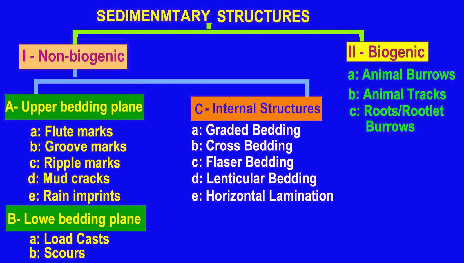
Types of Sedimentary Structures: We recognize two principle types:
Primary sedimentary structures: occur in clastic sediments and produced by the same processes (currents, etc.) that caused deposition. Includes plane bedding and cross-bedding.
Secondary sedimentary structures: are caused by post-depositional processes, including biogenic, chemical, and mechanical disruption of sediment.

As sedimentologists, we care about sedimentary structures because of their wealth of information about the environment of deposition. We will focus on primary sedimentary structures in this lecture; later, we'll go into depth about some chemical and biological structures.


Primary Sedimentary Structures

Plane bedding

Bedding forms as a direct consequence of Steno's law of lateral continuity, that holds that a unit of sediment will extend laterally to the physical margins of the basin it is filing:

"Material forming any stratum were continuous over the surface of the Earth unless some other solid bodies stood in the way."

We perceive plane beds because of changes in the composition or grain size of sediment during deposition. This, in turn, reflects changing rates of deposition. Three basic mechanisms can form plane bedding:
Sedimentation from suspension
Horizontal accretion from a moving bedload
Encroachment into the lee of an obstacle.

Our perception of bedding is a function of scale. At the largest scale, successions of undisturbed formations may appear as superposed beds, however at finer scales, these resolve into other sedimentary structures that may not be strictly planar.


When bedding persists at fine scale (< 1cm) is called lamination.

In what depositional environment would one most likely expect to find plane bed laminations?
One possibility
Another

Factors might disrupt fine scale laminations in mudrocks include:
Flocculation of clays - clumping before particles settle
Bioturbation - disturbance by organisms (right)
 
 
Support : Creating Website | Johny Template | Mas Template
Copyright © 2011. petroleum companies - All Rights Reserved
Template Created by Creating Website Published by Mas Template
Proudly powered by Blogger